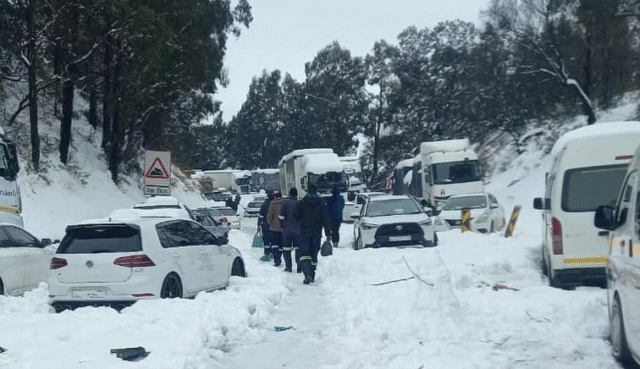
Weather warnings:South Africa has issued twelve weather warnings, indicating the possibility of snow, rain, wind, and waves.
A Synopsis of the Weather System
All provinces except Limpopo are currently being affected by the cold front, which has already affected the Western Cape.
Strong winds, rainy weather, and widespread frigid temperatures are all caused by this cyclone.
In several areas, daytime highs will stay below 10°C, making the colder weather even more severe.
Residents and authorities are advised to pay attention to all weather warnings from the South African Weather Service (SAWS) and to be ready for dangerous situations.
The Gauteng
On Tuesday, June 10, 2025, a powerful cold front will pass through Gauteng, bringing with it very cold and largely dry weather.
It is predicted that daytime highs will peak at about 11°C, while early morning lows will dip to almost freezing, and in some places, as low as -1°C.
Compared to typical winter norms, this dramatic temperature drop represents a considerable chill.
Residents in Gauteng’s southern and southeast regions should brace themselves for partly overcast sky with isolated to scattered showers and thundershowers.
Cold weather and the possibility of snow have been warned by the South African Weather Service (SAWS), especially in higher elevation regions between Johannesburg and Pretoria where there is a potential of light snowfall or frost.
Gusty winds brought on by the cold front could raise the windchill factor and make it feel colder than it is.
Outdoor activities and early morning commuters may be impacted by these conditions.
Wearing warm clothing, using heating carefully, and keeping an eye on vulnerable populations including the elderly, young children, and pets are all recommended.
With only one or two rainy days predicted for the month, Gauteng is only projected to have light and intermittent rainfall.
The Free State and Eastern Cape are under a snow warning.
The Eastern Cape and some areas of the Free State are predicted to see disruptive snowfall. The maximum impact level for snow, Orange Level 6, has been issued by SAWS.
Road closures, community isolation, and potential fatalities could result from this storm.
Several local municipalities have issued additional Yellow Level 2 warnings for disruptive snow.
In some places, snowfall can result in ice roadways that cause traffic jams and animal losses.
Risks of flooding and heavy rain in KwaZulu-Natal and the Eastern Cape
A significant portion of the Eastern Cape and southern KwaZulu-Natal will see heavy and disruptive rain.
Several towns have issued orange level warnings due to the potential of floods.
Flooding can result in mudslides, block off towns, and damage property. Residents should be cautious, particularly in places that are prone to flooding.
The middle and northern interior of KwaZulu-Natal are under yellow alerts, while the southern portions are under Orange Level 5 warnings for destructive winds and rain.
There is also a yellow warning for disruptive rains in KwaZulu-Natal’s extreme south.
Coastal hazards and strong winds
High waves and damaging winds are predicted for the KwaZulu-Natal and Eastern Cape coastlines.
An Orange Level 6 warning indicates that winds and waves could disrupt ports, damage structures, and endanger ships at sea. There is an Orange Level 5 warning for destructive winds that might cause harm to individuals and damage to communities in southern KwaZulu-Natal.
The KwaZulu-Natal coast is also under a yellow warning for destructive gusts and waves on Tuesday and Wednesday. Strong interior winds can impair transportation and agriculture in inland areas.
Limpopo, North West, and Mpumalanga
Conditions will be cold but mainly dry in the majority of the inland provinces. Early morning lows in some places will be close to freezing, while daytime highs will be between 12°C and 24°C.
The Western Cape
Heavy rain warnings are still in place, and the cold front is still causing damp and chilly weather across the Western Cape.
Advice on Safety and Preparedness
Considering how serious the weather forecasts are, locals and visitors should:
Steer clear of needless travel in places hit by snow.
Secure your property and keep yourself updated through official channels in case of flooding.
Be cautious when you’re close to the coast because of strong gusts and large waves.
Regularly check for updates from local authorities and the South African Weather Service.
Keep yourself warm and safe.
One of the strongest weather systems to affect South Africa this winter is this cold front. Strong gusts, snow, and rain will cause disruptions to everyday life. To stay safe in the upcoming days, it is essential to remain vigilant and heed weather warnings. In order to be safe and warm, residents should take the appropriate steps and stay informed about weather advisories.


